Blue
Mountains mtb rides
Narrow Neck
I really should do this ride more often. As usual, there I was on the train, getting excited as I started to glimpse some of the spectacular views I'd soon be riding. At Wentworth Falls you get your first glimpses of the Jamison Valley to the south - rolling green bushland fringed with spectacular sandstone cliffs, and the views only get better as you roll towards Katoomba.
Narrow Neck video (one way out - 6:06)
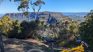
| No, the name doesn't refer to computer geeks, it refers to a narrow strip of ridge in Katoomba. If the valleys were still filled with water, Narrow Neck would be an isthmus. Narrow Neck separates Jamison and Megalong valleys and provides a bountiful supply of the spectacular views that make the Blue Mountains world renowned. | 
|

Dogface, aka the Landslide |
Catch the train to Katoomba station and head west - either side of the railway line will do. Turn left off into Cliff Drive - well marked as a tourist route. This road is mostly called Cliff Drive - I say mostly, because at one stage it becomes Narrow Neck Road, and then turns back into Cliff Drive. Although there's a dirt turn off signposted Narrow Neck Road, it isn't the road to Narrow Neck... Keep going till you see Narrow Neck Lookout. |
|
Stop
for a look, and you can see Narrow Neck Plateau to the south, Megalong Valley to the west, and Mt Solitary to the east. Turn right
out of the lookout then right into
Glen Raphael Road, and you are on the Narrow Neck fire trail.
I wish their naming conventions were a little less confusing!.
Glen Raphael Road plunges down towards the valley in twists and turns, but be careful, as this bit's two way and used by all sorts of vehicles. At the moment, it's got some big corrugations to loosen those fillings. Soon the downhill stops, and you are faced with an enormous climb to the gate. At one point the hill has been concreted to aid traction - it doesn't help me get up it though! Stop press! I got up it in October 2015! Sure, I was in super granny gear, and I was as slow as a wet weekend, but I don't care, I've finally done it! After the gate the hazards are bushwalkers, other cyclists and in winter, there may be ice on the track even in the afternoon. Keep your eyes open! |
Eventually
you reach the Narrow Neck that gives the trail its name |

a few big climbs |
 Mark Hodges photo - Wildtrek Photography |
By the end of the trail you'll have seen the upper waters of Lake Burragorang, Sydney's water supply, Mt Solitary, the Ruined Castle and the Landslide (Dogface) to the east, the Southern Highlands, Kanangra Walls and the Jenolan Caves area to the south, and endless sandstone cliffs, views, views and more views all around. On a clear day you can even see Centrepoint Tower in Sydney. There used to be a plaque cemented to the rock at the lookout in memory of a young man, but it's disappeared. I don't know if he fell, jumped or just liked the area, but the plaque was a good reminder to be careful - it's a l-o-o-o-n-g way down. Take the short steep walk to your right at the end of the trail to Taros Ladders - you should probably hide your bikes and chain them up somewhere if you do this. The ladders are a series of spikes fixed into a rockface to aid climbing - a very easy climb of around 20m. Some riders have abseiled off here with their bikes to get to the valley, but that can take you into catchment area - where you shouldn't be, at least according to Sydney Water. |
I regard the trail as a medium to hard ride - there are a several large hills that I have to walk - but then again, that gives plenty of reasons to stop, breathe, and enjoy the views. The track surface overall can be variable - in some spots it can be rough, loose and gravelly, and in others smooth with government supplied jumps. In June 2015, the track was in good condition, although there were a few erosion ruts - notably past the fire tower. |
 Mark Hodges photo - Wildtrek Photography |
It's about 5 kms from Katoomba Station to the Glen Raphael turnoff, another 3 kms to the gate and then around 10 kms to the end - 26 kms of dirt all up - or you can drive to the gate for a 20 km round trip.
This is undoubtedly the most spectacular ride I have done in the Blue Mountains. In October there were lots of waratahs to admire at the side of the track, and plenty of other spring flowers. Then there are the truly, genuinely, fanbloodytastic views. If you think I sound impressed - you're right. I am! As long as beginners don't mind pushing their bike up some steep climbs, I think they'll like it too.


Elevation from start of Glen Raphael Drive to end of firetrail
| Distance | ~36 km return to station |
| Type | sometimes loose and rocky fire trail, lots of waterbars, car free from gate to end and back (occasional maintenance vehicles excepted) |
| Difficulty | Medium/Hard - will probably need to walk some uphills. Surface may be loose and rocky. |
| Time | Varies - from a few hours to all day |
| Trains | Katoomba - timetable |
| Interest | Echo Point, Three Sisters, views, many bushwalks, views |
| Issues | Popular with bushwalkers, slow down and say hello, ride lightly, don't skid down the hills, take out all your rubbish |
| Ridden | April 2024 |
![]()
another fAt hIpPy production


